For Garmin GPS receivers and Mapsource.
Last updated: 19 Dec 2005
Using “Contours” on the GPS receiver
|
For Garmin GPS receivers and Mapsource.
|
Last updated: 19 Dec 2005 Using “Contours” on the GPS receiver |
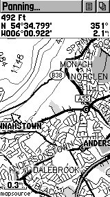
For clarity, most of the screenshots in this section have been taken from a Garmin iQue 3600. Most mapping units behave and display in a similar way, although controls and menu structure will differ. Known differences in other models of GPSr are highlighted in the text, where necessary.
Viewing the contour maps:
|
When first uploaded to your GPSr, it's almost certain that the contours will show on its display by default. If this is not the case, go into the “Map Preferences” menu - wherever it is - and make sure that “Contours” is switched on. On the B&W eTrex range, this is done from the map display itself, by clicking the menu button, then “Setup Map” and click on the “i” icon. On the iQue (various models), the same function is under “Preferences” > “Detailed Maps” The modern GPSMap60/C/CS range, go to “General Settings” > “Map Setup” > “Information Settings”. Colour eTrex Legends and Vistas have almost the same menu structure as the GPSMap60C. GPSMap76: Go to “Setup Map” > “Map” tab > “Mapsource” |
|
Performance:
Except on the B&W eTrex range, no significant effects on screen re-draw performance have been found when adding Contours to the existing detailed maps. The “old” eTrex models have very little processor power to spare, and any screen with a high detail content will be slower than usual to draw. On eTrex, it may be useful to switch off Contours if most of the navigation is being done in built-up areas.
Detail and zoom:
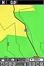
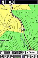
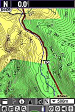
At large scales, the contours should be visible at 10m intervals. Zoom out, and eventually only the major contours (250m intervals) will display. This is controlled by the “Detail” setting on most GPS units – NOT by the “Topo” setting (if there is one) because these are not Garmin Topographical maps. The following screenshots illustrate the effect of moving the “detail” slider on an iQue 3600, maintaining the same view and level of zoom. (The area shown is in N. Wales.)
|
|
|
|
|
Detail minimum |
Detail centered |
Detail maximum |
To finish with, a final caveat about using contour maps (or any other kind of maps, for that matter) on a GPS receiver: These maps are only a guide to the terrain likely to be encountered in the navigation area. They do NOT include landscape features which are small scale – but still big enough to hurt: cliffs, scree slops, boulder fields, and so-on. Please use your GPS with care and common sense when out and about.
Walk safe.
![]()
|
Contents.... |
|
|---|---|
|
|
|
|
|
|
|
Page 1: |
|
|
All text and images on this website are ©Paul McMichael 2005, and may not be copied or reproduced. We sue. “Mapsource”, “iQue”, “eTrex” are registered trademarks of Garmin Inc. |